| The
Meredith House |
|
|
|
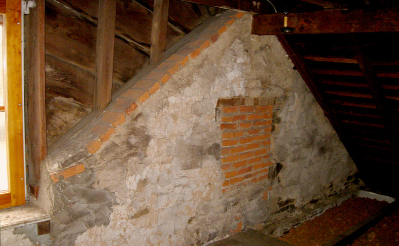
| The top of the
stone house as seen from inside the attic. This is facing the front. |
| |
|
|
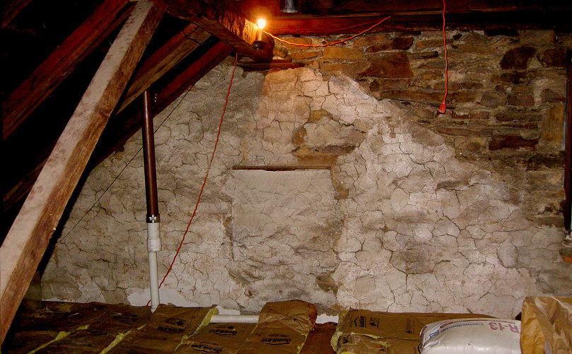
| Top of the stone
house facing the back. |
| |
|
|
| There is no
indication that the log house was ever as high as the stone house. |
| |
|
|
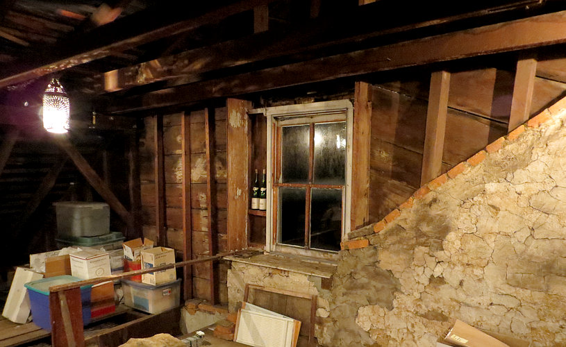
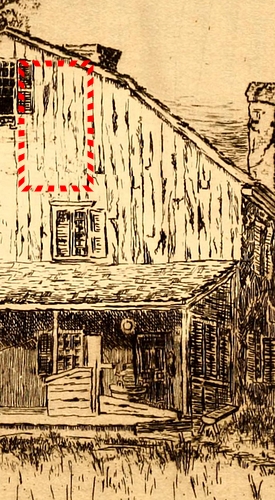
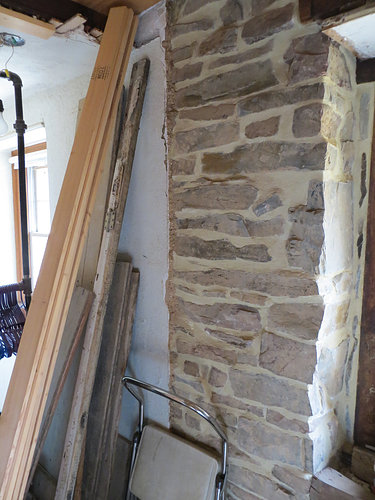
| Inside the attic
over the log house and the approximate location in the drawing. |
|
|
|
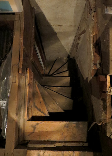
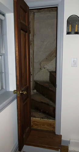
Looking down the
attic steps. The steps were built over the log house and lead from
an upstairs bedroom.
The wall of the stone house was in the way, so they turned them.
It appears they were turned 180 degrees, then
later turned back 90 degrees with the addition of the top step. The doorway to the attic is only 16 inches wide. |
|
|
|
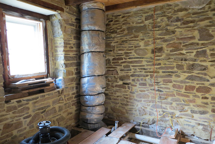
| 2nd floor, rear
of the stone house under de-construction. This was all plastered.
Someday it will be a bathroom. |
| |
|
|
|
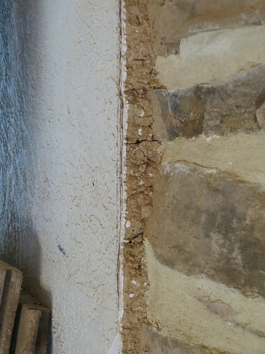
Over the stone was a "brown coat"
consisting of mud, horsehair and lime. Over the brown coat
was a layer of plaster.
At some later date, someone thought an additional
layer of "textured" plaster would be nice. This has all been
chopped out and the stone has been pointed. Was the brown coat applied and plastered over at
the same time the stone house was built? There seems to be
plaster over the stones in the attic, but it's very rough. |
|
|
List of owners:
|
Owner (Date of occupancy)
Thomas Evan (1698) Purchased
Gwynedd Township with William John.
Owen Evans (1715) son of Thomas Evan. 306 acres.
Samuel Evans (1757) son of Owen Evans.
Amos Roberts (1765) deed from Samuel Evans. 88.5 acres
Caleb Foulke (1776) Known as the Caleb Foulke Farm. Died in
1811
Caleb and Charles Foulke (1811) Sons of Caleb Foulke
Jane Foulke (1813) Widow of Caleb Foulke. By way of sheriff
sale
Dr. Joseph Meredith (1814) Medical doctor, died in 1820.
Note: Dr. Meredith was married to Rachael Foulke of Gwynedd.
It
is possible that Rachael was the sister of Jane Foulke
(above).
E. (Edward) Meredith (1848)
Edward Meredith, Farmer. Age 58. (1850) Same as above.
Also, Hannah age 42 and Margaret age 39.
E. Meredith (1857) Same as above.
J. Lukens (1871)
John. Lukens (1877) Same as above.
Jonathan Lukens (1884) Same as above.
Sarah Lukens (1891)
Sarah Lukens (1893) Same as above. Died 1900.
Naylor Lukens (1897) Died 1910.
E. A. Perry (1909)
Lester B. Johnson (1916)
Joseph and Myra Ford (19??)
Georganne
and Adrienne Ricketts (1954)
Fred Arias and Andrea Havens (1998)
Andrea Havens (2006) |
Source
Historical Collection
Relating to Gwynedd
Historical Collection Relating to Gwynedd
Historical Collection Relating to Gwynedd
Historical Collection Relating to Gwynedd
Historical Collection Relating to Gwynedd
Historical Collection Relating to Gwynedd
Historical Collection Relating to Gwynedd
Historical Collection Relating to Gwynedd
Wm. E. Morris 1848 Map of Montgomery County
Montgomery County, PA Census of 1850
1857 map of Montgomery County
G.M. Hopkins 1871 Atlas of the county of Montgomery
J.D. Scott 1877 Atlas of Montgomery County
Historical Collection Relating to Gwynedd
G. Wm. Baist Atlas of Montgomery County
1891
J. L. Smith Atlas of Montgomery County 1893
Ambler Gazette September 2 1897
Ambler Gazette December 9,
1909
A. H. Mueller Montgomery Co. North Penn Section 1916. Plate
29.
Montgomery County PA property records
DEED
Montgomery County PA property records
DEED
Montgomery County PA property records
DEED
Montgomery County PA property records |
|
|
|
|
| West side of the
house. This faces a house that used to be a barn. |
| |
|
|
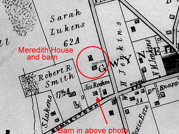
The barn, now a
private residence.
|
The Jenkins book refers
to the area (in 1884) as "the Meredith farm" although John
and Sarah Lukens had owned the property since at least 1871. In 1885
Sarah Lukens had the house at the
corner of Sumneytown Pike and Swedesford road built, along
with this barn. Sometime
before 1891 she sold the house and barn to Joseph Roehm.
|
|
|
|
| |
The map above (Baist map of Montgomery
County 1891, Plate 11) shows that by 1891 Sarah Lukens, who
still owned 62 acres, had sold
the corner house and the barn to Joseph Roehm. There is
another barn on Sarah Luken's property connected to the
Meredith House. This barn was demolished in 1909 when E. A.
Perry owned the property. Today there is a residence at the site of
this barn. The owner occasionally digs up an artifact in his
back yard.
To complicate things there is another Lukens property at the
bottom-left side of the map. This house was built by the
Lukens in 1875. The beautiful house is still
there today, along with the barn, at the corner of
Sumneytown Pike and Barberry Road.
Jonathan Lukens owned a saw mill
and 90 acres of timber on West Point Pike. He built a train
station on the Pike when the Stony Creek Rail Road came
through in 1875, and for several years the village that
sprang up in the area was known as "Lukens Station."
When a post office opened there in 1878 the name of the
village officially became "West Point". Lukens sold the saw
mill that same year. He owned a large tract of land in what
is known today as Ambler. Many of the streets in Ambler were
laid out by Lukens, who also built some of the first houses
there.
Jonathan Lukens died in 1884. Sarah died in 1900. They had a
son named Naylor, which was also the name of Sarah's father.
(See list of owners above.) Naylor died on December 29,
1910. The location of his death is listed as "North Wales," so we
might assume he still lived in the house or at least owned
it.
|
|
|
|
|
The
1916 A. H. Mueller map (Plate 29) shows
the corner property to be owned by Isaac
Hetzell. Hetzell named his property
"The Cedars." There are still one or two
cedar trees on the property, descendants
of Hetzell's cedars.
According to the Mueller map, by 1916
Owen Evans' 306 acre property had been
reduced to a measly 6.5 acres. At that
time it was owned by Lester B. Johnson
who subdivided it into 250 lots,
surveyed in 1909. However, 110 years later
there are only about twenty properties
in the immediate area. The Meredith lots
are numbers 76 to 82, stated on the deed
for the house.
Presently, the
barn, Hertzell's house on the corner and
the Meredith house are all individual
lots separated by fences and shrubbery.
5th Street was never built and is now a
line of trees growing between Gwynedd
Avenue and Swedesford Road.. |
|
|
|
| |
|
|
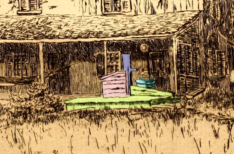
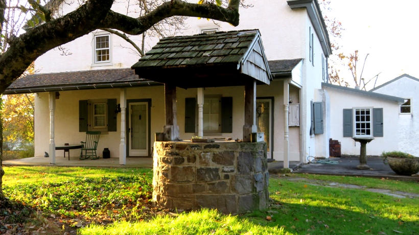
| The well (and a
bucket). I'm not sure what the wooden box is for. |
| |
|
|
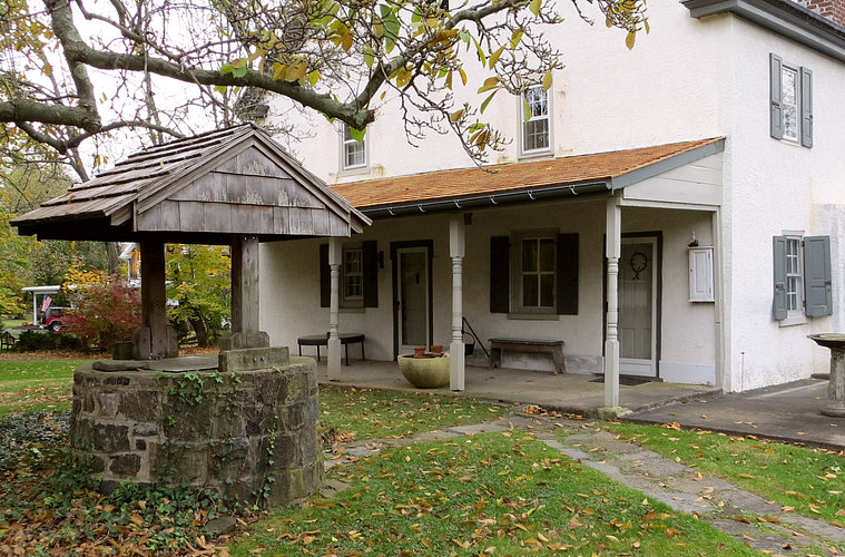
| The well in the
drawing looks flat because there is a little hill in front of it. |
| |
|
|
| The hill has
been gone since at least 1910, when the house next door was built. |
| |
| |
|
|
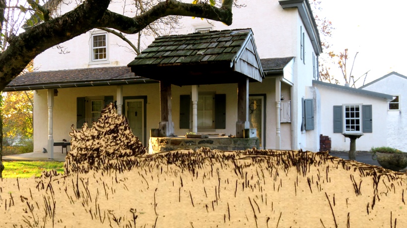
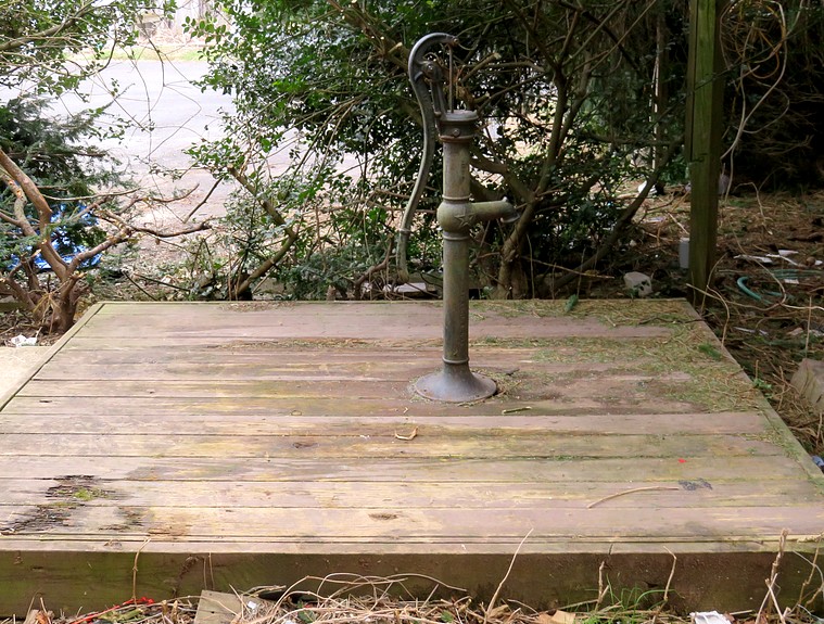
Roughly rendered
in the drawing, the well cover and pump may have resembled this one.
This is located in West Point, PA, about three miles distant. |
| |
|
|
The still functioning well is less than
20 feet from the front door of the log house.
A metal plate is padlocked to the top to prevent the disappearance of
neighborhood children. |
| |
|
|
|
|
|