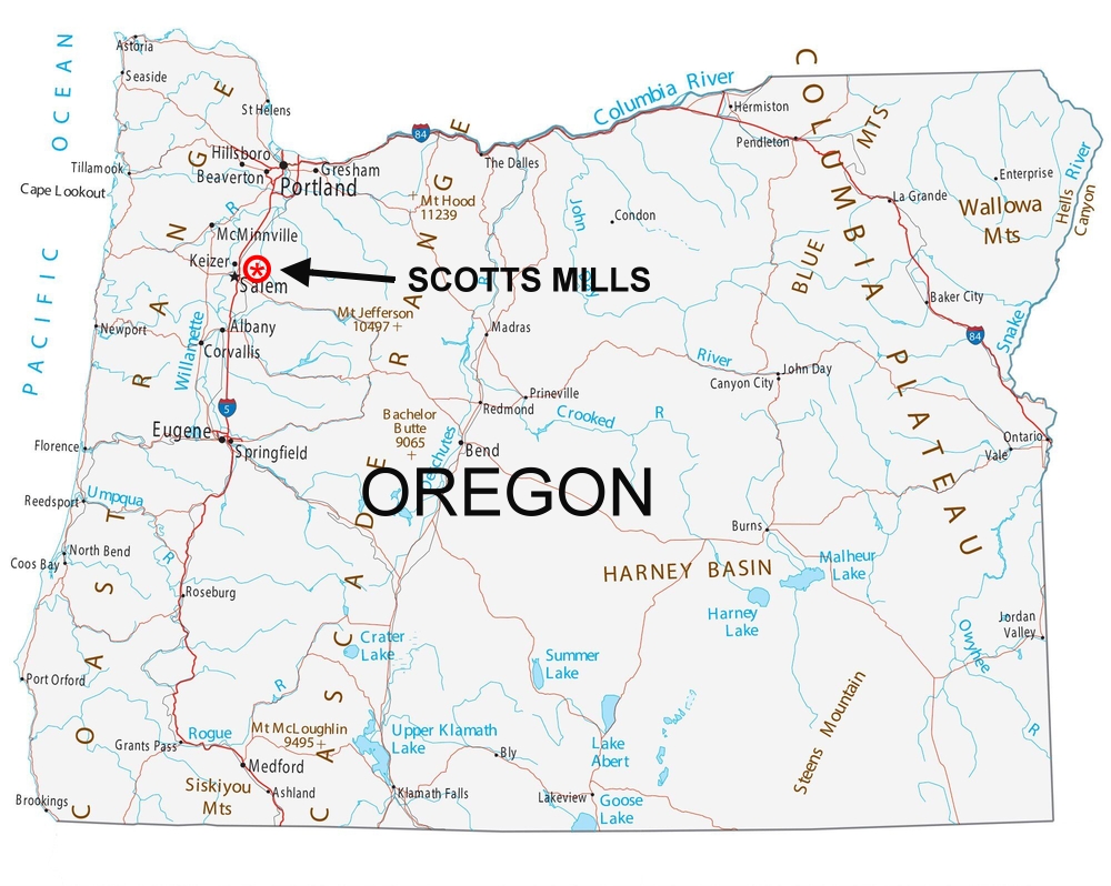
Location of the Charles Osterhoudt
farm derived from a mortgage
dated June 7, 1887
Newspapers and other sources state
that Charles Osterhoudt moved to Marion County Oregon from
Illinois in 1866, along with at least two of his brothers,
Hiram and Elias. However, the 1880 census shows the entire
Charles Osterhoudt family living on a farm in Waverly,
Bremer, Iowa. Elmer's father William was born there in 1870.
In 2007, a distant family member related that part
of the Osterhoudt family arrived in Oregon from Waverly,
Iowa in 1884. They returned to Iowa, then moved back to
Oregon in 1895. This means that Charles' 1866 move to Oregon
was temporary since he was back in Iowa in 1870.
Charles apparently traveled to Oregon a second
time in 1884 and and either purchased or mortgaged a farm in 1887, according to the
document shown below. The mortgage shows the signature of
his wife Betsy, but it's in the same handwriting as Charles.
This makes it impossible to determine if Betsy was actually
with him or not. The mortgage was paid in 1890. It's not
known if they left for
Iowa and
returned again to Oregon in 1895, or if they stayed in
Oregon and the rest of the family came out in 1895. Betsy died there in 1896.
Though these dates seem to be correct, the exact sequence of
events may never be known.
There are no census records from 1890, as they were
destroyed in a fire on January 10, 1921, but the 1900 census
shows the family living in Marion County Oregon, on a farm
near Scotts Mills, Oregon. This is where Elmer was born.
According to the Scotts Mills Historical Society, a fire in
the Marion County Courthouse in the early 1900s destroyed
all property records. This makes it impossible to find an
actual deed to the Charles Osterhoudt farm where Elmer was
born, but the mortgage document shown below gives the
location.
Notes concerning the text in the document:
Charles and Betsy Osterhoudt were Elmer Osterhoudt’s
grandparents. Elmer was born on their farm. Betsy Osterhoudt's maiden name was Woodruff. Cornelius Woodruff was Betsy's father. Sarah H. Coffin was Betsy’s sister.
Donation Land Claim – The Donation Land Claim Act of
1850 granted 320 acres of land to every white settler or
“half breed Indian.” A married couple received 640 acres.
The Osterhoudt farm was located on the DLC of Thomas P.
Jack.
Chain – A chain is a unit measuring 66 feet in
length. There are 80 chains in a mile.
The “county road leading to Silverton” is now route
213, or Cascade Highway. Charles and Betsy are buried in
Miller Cemetery on Cascade Highway, about one mile from the
farm described in the mortgage. Also buried there is Luella
Dicken, one of their daughters, sister of Wilbert Osterhoudt
(Elmer’s father) as well as Elmer's mother, Minnie.
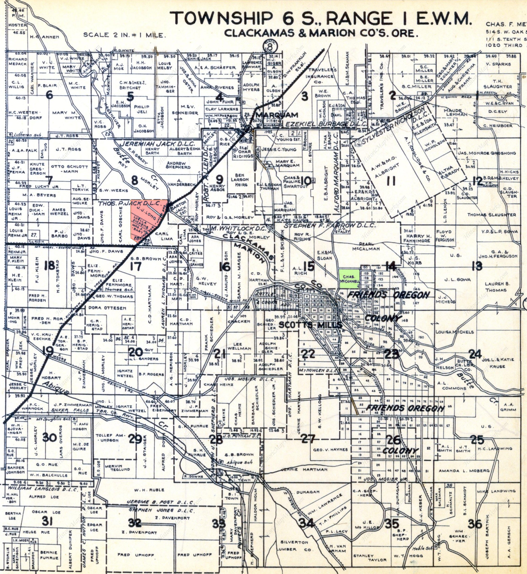
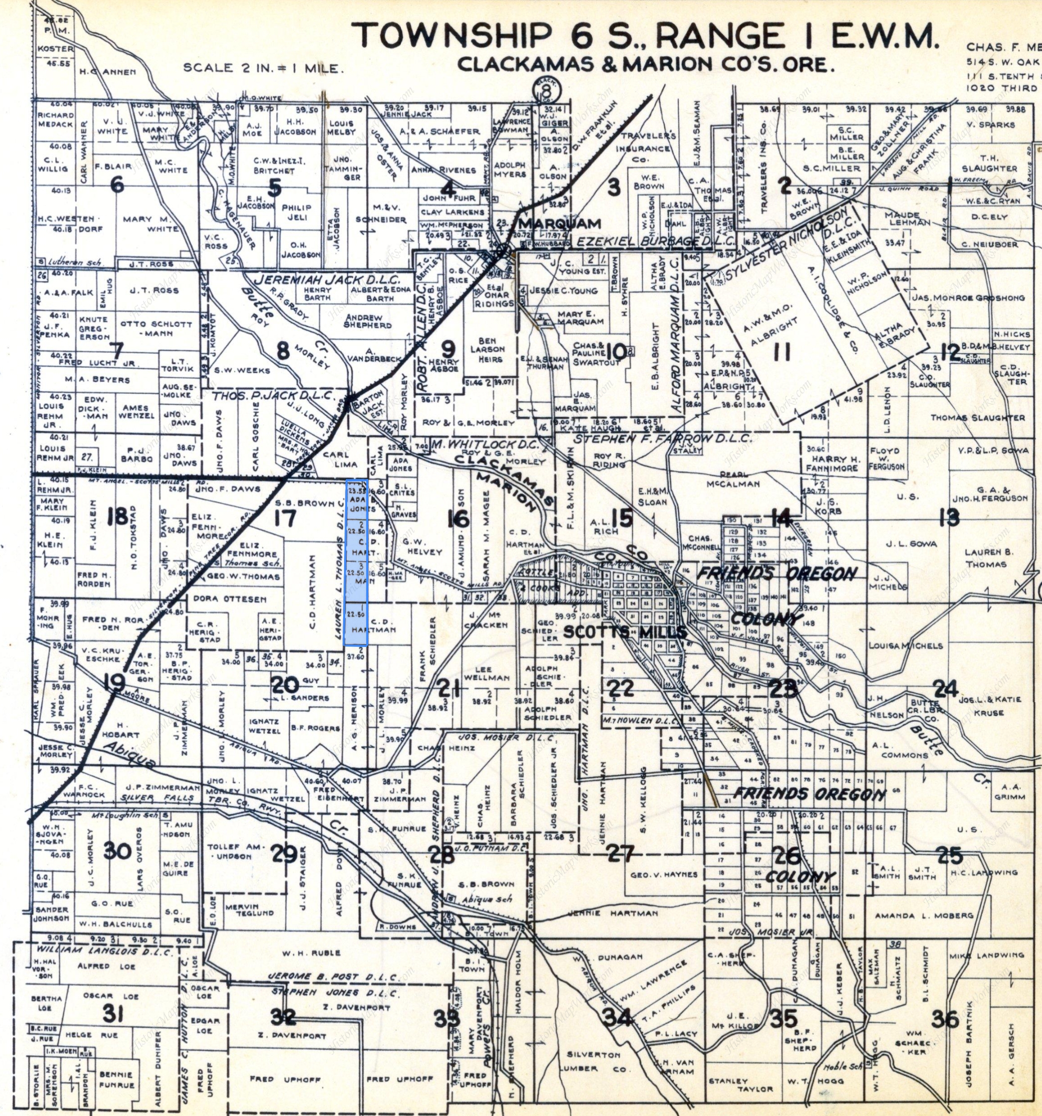
“T. 6 S of Range one (1)” is a map from Metsker’s Map
of Clackamas County, Oregon. It is shown below the mortgage
deed.
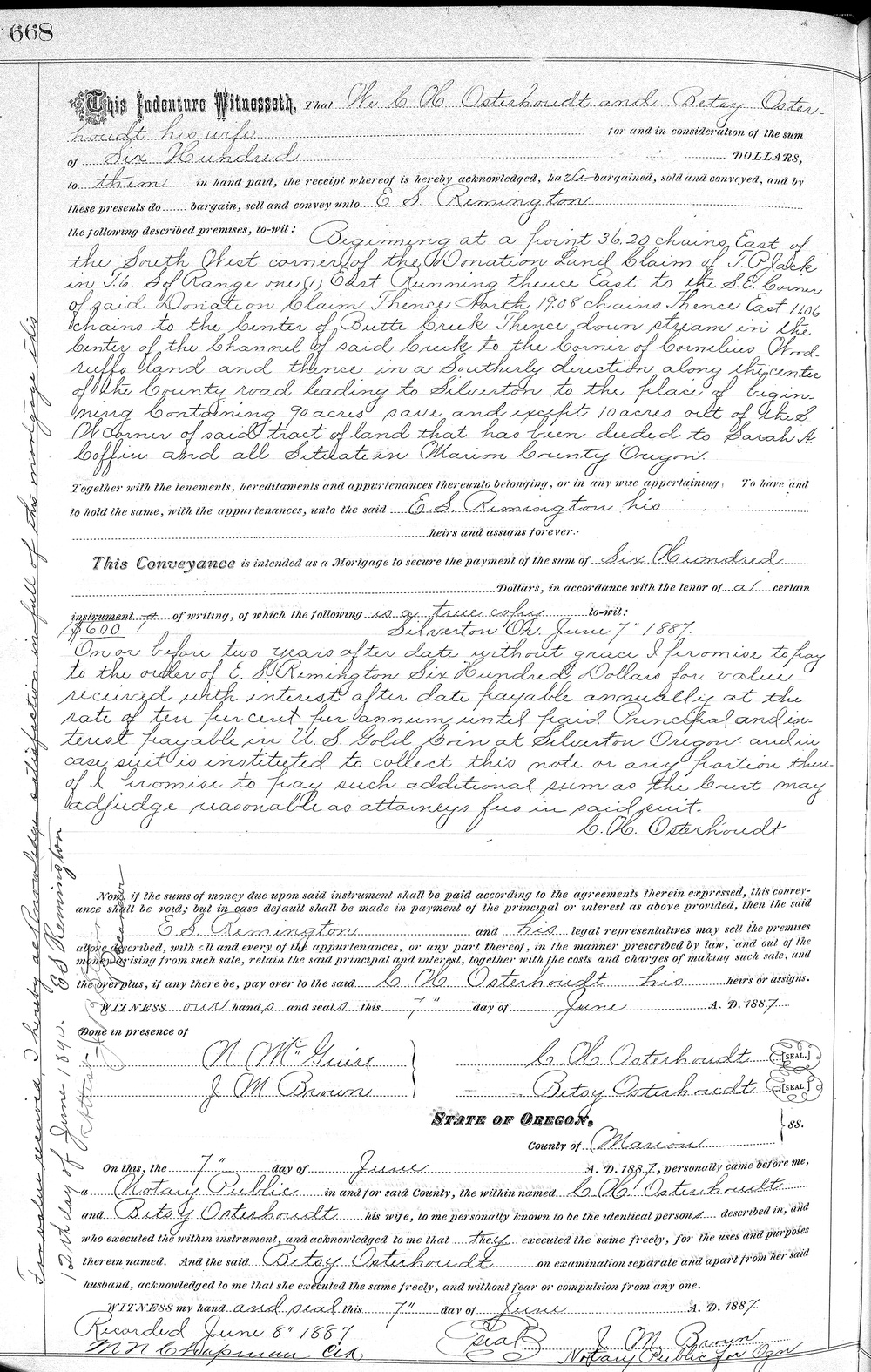
Partial Transcript:
This indenture Witnesseth that We C H Osterhoudt and Betsy Oster-
houdt his wife for and in the consideration of the sum
of Six Hundred DOLLARS
to them in hand paid, the receipt whereof is hereby acknowledged,
have bargained, sold and conveyed,
and by these presents do bargain, sell and convey unto E S Remington
the following premises, to wit: Beginning at the front 36.20 chains
East of
the South West corner of the Donation Land Claim of T. P Jack
in T. 6 S of Range one (1) East Running thence East to the S. E.
Corner
of said Donation Claim Thence North 19.08 chains Thence East 11.06
chains to the center of Butte Creek Thence down stream in the
center of the channel of said Creek to the Corner of Cornelius Wood-
ruffs land and thence in a Southerly direction along the center
of the county road leading to Silverton to the place of begin-
ning Containing 90 acres save and except 10 acres out of the S
W corner of said tract of land that has been deeded to Sarah H.
Coffin and all Situated in Marion County Oregon
Together with the tenements, hereditaments and appurtenances
thereunto belonging, or in any wise appertaining, To have and to
hold the same, with the appurtenances, unto the said E. S. Remington
his heirs and assigns forever.
This Conveyance is intended as a Mortgage to secure the payment of
Six Hundred
Dollars, in accordance with the tenor of a certain
instrument of writing, of which the following is a true copy to-wit:
$600 Silverton Or. June 7 " 1887.
(Charles Osterhoudt then promises to pay the mortgage within two
years at 10% interest in US gold coin or E. S. Remington can sell
the property to cover the debt. Along the side of the
document is a note by E. S. Remington stating the mortgage was paid
in full on June 12, 1890.)
The description is confusing, but
the pink shaded area above seems to be the 90 acres
mentioned in the mortgage document. Butte Creek is
shaded blue. This map is from 1937, long after the
Osterhoudt's had left the area. A plot owned by
Loulla Dickin(s) helps to confirm the location, as
Loulla was one of Charles' daughters. On this map,
"the county road leading to Silverton" is named
"Silverton - Pine Tree Corners Road."
In green, above the word "FRIENDS" was the
farm of Charles and Nellie McConnell. Nellie
McConnell was also one of Charles' daughters.
Elmer's brother Cyril lived with the McConnells
during his childhood.
The red cross marks the location of Miller Cemetery,
where Charles, Betsy, Minnie and other family
members are
buried.
Click on the map for a larger version. View the area
as it is today with this link to
Google Maps.
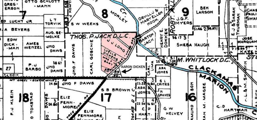
Here is the
location on a map from 1929. (The correct
spelling of "Luella Dickens" name is Loulla Dicken)
Below the pink shaded area is a
small triangle with the number "29" inside. This was
owned by Aaron and Loulla Dicken (formerly Loulla
Osterhoudt). To the left of this on the other side
of the road would have been the ten acre property of
Sarah Coffin, Betsy Woodruff's sister. The deed
states that the Osterhoudt property ran down the
center of the creek to the corner of Cornelius
Woodruffs land, then down the center of the road.
Where I have typed "Aaron Dicken" on the map might
be the Woodruff property. It is interesting that the
Charles Osterhoudt farm adjoined the Cornelius
Woodruff farm, the Dicken property and the 10 acres
belonging to Sarah Coffin, as all these people were
related. They are all buried in Miller Cemetery.
In the 1900 Census, the Dicken household was the
next dwelling in order of visitation after the
Charles Osterhoudt household, but as can be seen on
the 1929 map, Loulla Dicken later owned a tract
where the Osterhoudt farm was located. Somewhere in
the pink shaded area was the farmhouse, most likely
in the area owned by Loulla Dicken.
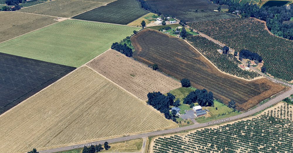
Buildings on the place where Loulla Dicken's
property is shown on the Metsker's map.
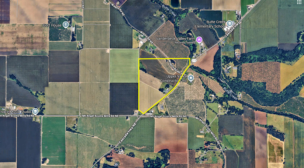
The address above is 8967 Cascade Highway,
Silverton, Oregon. It is perhaps the exact site
where Elmer and Cyril Osterhoudt were born. To the
right is the property of Loulla's neighbor, J. Long,
at 9712 Wagon Road, Mount Angel, Oregon. Though
they're next to each other, they're in two different
zip codes. The property is one mile closer to Mount
Angel than it is to Silverton.
The Dicken family in 1899. Aaron is 40 and Loulla is 39.
Left to right: Charlie, Aaron, Cora (standing),
Carrie, Era, Frank, and Loulla
Photo thanks to
September Karrigan
Additionally, according to
this tax record from 1895, Charles owned another
80 acres. 25 of them were cultivated, the rest
supported 3 cattle and 50 sheep and goats. The
approximate area is shaded blue above. Though
Charles owned at least these two tracts, the house
where Elmer was born was in all likelihood on the
upper tract, which bordered Butte Creek.
About 22 miles to the Southwest
was the farm of Charles' older brother, Hiram D.
Osterhoudt. Hiram died on June 8, 1900, leaving his
farm to his son Edwin and two daughters, Allie G.
Farnham and Mary A. Sweet. The estate was valued at
$5000. Allie was the only one who actually lived in
Marion County, and on October 17, 1900, Edwin sold
his share to Allie for $750 (equal to $29,000 in
2025).
Edwin was divorced at the time but he must have
gotten re-married. The Daily Journal, July
13, 1901, and The Weekly Oregon Statesman,
January 14, 1902, report that Mary sued Edwin and
his wife, as well as Allie. Edwin had borrowed $2000
from his father in 1897, and was indebted to the
estate. Mary wanted the tract of 267 acres to be
partitioned accordingly. It was reported on January
24, 1902 that the property had been "distributed
among the rightful heirs."
Let's think about
this; Edwin's share probably didn't even cover what
he owed, but he walks away with $750 and Allie now
owns 178 acres of farmland. Meanwhile, Mary is
wondering what the heck just happened, how does
Allie now have twice as much land, and why does her
brother think it's OK to cheat his sisters out of
$2000 ($77,140 in 2025). It's too bad Mary had to
resort to a lawsuit to straighten things out.
On the
1929 Metsker map, Allie Farnham still owned the
farm, though the acreage seems to be reduced. The
location is where the number "22" is written in bold
on the map.
A tax assessment from 1895 shows Hiram had 267 acres
of land, 100 of which were cultivated. He also had
72 sheep and goats, 3 horses, farm implements, $50
worth of household goods, and $300 cash. Apparently,
houses and barns weren't listed directly, but he had
$400 of "improvements" on the land.